Sunday, May 31, 2009

Butte-iful

Day 24: 75 miles - Last night we were trying to avoid paying for a campsite while still being close to shelter from the iffy weather. We hung around downtown Debois for a while and eventually ran into a guy named Josh who offered us the front yard of his dentist office. It worked out perfectly since it was less than a block from the public restrooms where we hung out for the rain and cooked some dinner. We waited to put up the tent until some of the rain had passed, so we ended up having a nice dry night on his patch of grass.

This morning we got up and got rolling to Lander with a very nice tailwind. Combined with the gradual descent, we averaged 24.5 mph for the first 40 miles. After that, the wind shifted a little on us and the terrain became a little slower as well. Even with that, we still set an average record for the day at 20.5 mph and had covered 60 miles before 12:00 noon.
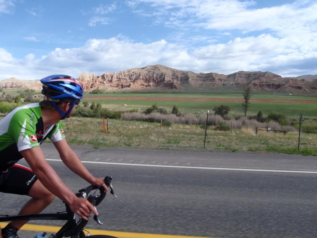
As we descended out of Dubois, we rode through some really beautiful red-rock canyons. The colors and shapes in the canyon walls were pretty captivating for the first bit of the ride. After that, we got out of the canyon and rode through some high desert pasture. At one point, we saw a lone horse in the field next to the road, so we called and whistled for it and got it to run along side us for probably close to a quarter of a mile. Just a few minutes later, there were two Pronghorn Antelope running along with us before eventually turning up the hill.


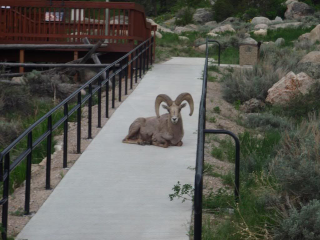
After getting into Lander, I called up some of my parents friends who invited us up to their house just out of town. Before dinner, we took a ride up to Sinks Canyon, where a river flows into this cave and then reappears about half a mile down the mountain. It was pretty interesting to see the river bubbling up out of the side of the hill. Also while we were there, a Big Horn Sheep made its way right up to the visitor center. Afterwards, we returned for an incredible dinner of antelope burgers, home grown asparagus, and homemade apple sauce. The best meal we've had on the trip by far.


Tomorrow we're going to try to get out of here early and make a long haul to Rawlins, WY. Hopefully the wind and weather will be with us, making the 124 miles doable. If not, we'll probably end up in Jeffery City for the night.

P.S. Apparently here you say, "ride with the wind" not "ride like the wind".

Saturday, May 30, 2009

Togwotee Pass

Day 23: 66 miles - Today we rolled out of Colter Bay and got a few last glimpses of the Tetons across the lake before heading up hill. Looking at the maps, I knew there was going to be a lot of climbing today - almost 3000 feet gain over 20-25 miles. As we started up, the grade was pretty moderate, allowing for a smooth, steady cadence. The first 10 miles of the climb passed pretty quickly and we stopped at the Togwotee Mountain Lodge to inhale a powerbar and take a breather. I didn't realize that we had already dealt with most of the elevation gain. From there, it was only slightly uphill for the next 5 miles and then a short 4 mile spike to the summit. After we crested the pass, Andy and I both commented on how much smoother it went than expected. The second highest elevation of the trip out of the way - no big deal.
On the climb, once we had gained a little elevation, we got a great view from behind of the Tetons and Jackson lake. Further up, we lost the view of Tetons behind us, but got to scope out the two peaks on either side of the pass. Also, we spotted a red fox part way up the climb. I think I was quick enough on the draw to get a picture, but I'll have to see later when I get them on a computer.
From the top, it was pretty much all down hill with a tailwind to Debois, WY. I don't think we really dropped below 25 mph for the 30 miles into Debois. Overall, the day was really pleasant and flew by much more quickly than I had anticipated.
Tomorrow we have a pretty gradual day to get to Lander, WY. Let just hope we don't have too much wind to fight. Wyoming is known as the windiest section of this trip.

Tetons

Day 22: 42 miles - Descending out of Yellowstone this morning, I saw probably the most snow all trip. In most places in the park, there was spotty snow but here, there was at least a 4 foot wall on each side of the road. We also rode by Lewis Lake which was still completely frozen over. It's weird to see both of these things when it's 65 degrees out wearing shorts and a jersey. After a ways further, we entered Tetons National Park and came up on Jackson Lake with our first view of the Tetons. The view of the mountains over the lake is probably my favorite thing so far. Being able to experience something that rugged is awe inspiring.


Tonight we're camping at Colter Bay just on the other side of the lake from the mountains. Tomorrow we'll be heading to Dubois, WY and hitting the second highest elevation for the entire trip over Togwotee Pass at around 9700 feet.

Yellowstone Lake

Day 21: 42 miles - Today we continued on our alternate route through the park at our super east rest day pace. We rolled out of Canyon Villiage early this morning and realized that we had missed a trail yesterday that led down into the canyon to the top of the falls. We figured we had all day so we took a hike, and it turned out to be really cool to see the canyon and falls from a lower vantage point. From there, we pedaled up the Yellowstone River to Yellowstone Lake. The view of the lake with the mountains was one of the most amazing views so far. Beyond that, we stopped at the West Thumb Geyser Basin where we saw more subthermal activity. At this location, there were actually geysers in the lake. Also, the geysers and springs here seemed much clearer and with a bunch of different tints and colors. We finished up the day in Grant Village in a campground that hasn't opened for the season yet.
At the campground, we ran into Nick again as well as another group of a guy and two girls from Wisconsin riding from Denver to Canada. Matt, Liz and Lacey were heading out tomorrow on the same route we took today to Canyon Village. Nick is actually going to bust out the last 80 miles to Jackson tomorrow to finish out his tour. Congrats on the completion.
Tomorrow we're heading out of Yellowstone and into Grand Tetons National Park to Colter Bay.

Yellowstone

Day 20: 41 miles - We had planned to take our time through Yellowstone to give the legs a little rest and so we'd get to see everything we wanted to. Our maps gave us a route through the park but didn't really give much on great places to stop. So for that, we stopped at the West Yellowstone bike shop Free Heel and Wheel for some advice on the way out of town. They convinced us that taking a route through Canyon Village and Yellowstone Lake would be more worthwhile than the route by Old Faithful that the TransAm map provided. So we headed into the park following the Madison and then the Gibbon rivers to Norris Geysers. Along the way we saw some great rivers along with some Bison and Elk. We stopped at Norris and took a little hike to check out all of the geysers. It's amazing that all that heat from so far down can be transferred to the surface. From there, we rolled on to Canyon Villiage. Once there, we took a hike down along the canyon to check out the falls. I really didn't know what to expect coming into it, but it was really amazing. The falls was over 300 feet tall and the canyon walls were over 1000 feet tall in some places. It was awesome to see the Yellowstone River flowing for miles through this deep canyon.


It turned out that the campground at Canyon Village was not open for the season so we rode around the village looking for a place to pitch a tent. We went down behind the lodge towards the area with the cabins thinking we might find some utilities. The cabins hadn't been opened for the season either, but they had been opened up to air out before guests arrived. So as we rode by, several of the cabin doors were wide open. We waited for it to get dark and then quietly pulled all of our stuff inside. Long story short, we got a free bed in a heated cabin courtesy of Yellowstone National Park. What a treat.

We also met a guy who started in New Hampshire in early April and is riding to Jackson, WY. He had planned to move there to work in a resort town and figured he'd just ride his bike there. He's only about 140 miles away, so he should be finishing up his 3000+ mile ride here in a few days.
Tomorrow we're planning on taking another short day, heading south to check out Yellowstone Lake.

Wednesday, May 27, 2009

Wind

Day 19: 72 miles - I started out this morning excited about the days ride partly because it would get us to the edge of Yellowstone and partly because I had a semi functional rear wheel. The profile showed a gradual gain of about 2000 feet over the first 55 miles so I figured it'd be a pretty fast day. We pulled out from our campsite on the Madison River and immediately had the wind in our face...and it stayed that way all day. After a slow, 4+ hour slog, we finally got to West Yellowstone, Montana.
Once here, my primary goal was to do something about my wheel. We rolled up to one of the bike shops and the owner agreed to help me. We left to unload and pitch the tent, then I went back to get to work. When I got back, the shop owner offered to let me use his tools and truing stand in the shop. So in a little less than an hour, I got the drive side of my wheel rebuilt with new spokes for only $18. It was super generous for him to give me free reign of the shop and a big relief to have a reliable wheel.
On the whole, I was a little disapointed with West Yellowstone. I knew it was a destination town, but I expected a little more character. There a lots of little retail shops but the feel honestly reminded me a little of Gatlinburg, TN.
Tomorrow we'll be heading into the park and into Wyoming. I'm not sure where we'll end up yet, but I'm excited about seeing the park and doing some exploring off the bike.

Taking chances...

Day 18: 72 miles - I got up this morning not knowing if we were going to ride today or not. I spent all morning calling everyone I knew asking for advice concerning this wheel dilema. The general advice was either "you're screwed in Dillon if you need bike work" or "you're only real option is try to get to west yellowstone". As a last ditch effort, we rode by the local bike repair shop that I had been trying to call all morning to find out that it was closed for memorial day. With no other decent options, we decided we'd head out and I'd be as gentle on the wheel as I could. I knew the big challenge for not doing further damage would be the 2000 foot climb about 55 miles in. We slogged through the first bit, fighting a headwind most of the way before coming up on the climb. I took it really easy up the climb, spinning as smoothly as possible, and topped out without any more spoke casualties. From there we had a nice panoramic 10 mile descent into Ennis. Coming down, we saw a bunch of pronghorned antelope and some whitetail deer, but I was too slow on the draw to get any pictures.
While we were getting settled, a group of three cyclists rolled into the area where we were camping. They had started in south Texas and were heading for Alaska. I started telling one of the guys about my wheel problem, and it turned out he had a cassette tool and a few spokes that were exactly the right length that he offered. So with his huge help, I got my two broken spokes replaced and should be able to make it West Yellowstone without any trouble.
So tomorrow, 71 miles to West Yellowstone and the end of Montana.

Sunday, May 24, 2009

Rain...

Day 17: 67 Miles - About an hour after I crawled into the tent last night, it started raining. I thought It'd pass over the night and not really be anything to worry about. Every time I woke up during the night, it was raining, and continued to rain all morning. We decided that it would be miserable to start our the day riding in the rain, so we bummed around Wisdom, MT until about 2pm. By then, the rain had let up and we rode on to the next town, Jackson, MT. We decided we'd take a chance on the next 45 miles, allowing us to get to Dillon, MT and fill our planned mileage for the day. We got over the first pass, the highest of the trip so far at over 7300 feet, with no problems and weather looking good. We cruised on to the second climb of the day and crested it with less than 20 miles to go. Looking good right? - wrong. With about 15 miles to go, the skies opened up and dumped everything its been holding back for th last two weeks. We thought we'd been able to sneek through the rain by delaying our start, but it found us in the end. I guess its better than having it rain all day or even starting in the rain.
Other than the rain, the day was great. Each climb was about 1000 feet with pretty good views off of either side. We also had a pretty good tail wind for most of the day which allowed us to finish with an average speed of 20.0 mph for the 67 miles, our best average for a day for the trip so far. We also had another best...our max speed for the day was 45.1 mph...try that with a fully loaded bike and a broken rear spoke.
Speaking of, while we're in Dillon, I've got to try to find some spokes to rebuild the drive side of my wheel. I've had a few spokes break here and there and have been able to get them fixed, but rebuilding it should solve these problems. So much for putting trust in a worn out wheel.
Tonight we treated ourselves to some shelter from the rain in a Super 8 in Dillon. Tomorrow we should be heading to Ennis, MT and then West Yellowstone on Tuesday.

Continental Divide

Day 16: 72 miles - We headed out from Hamilton on a pretty busy highway following the Bitterroot River south. This section of road was especially annoying with high speed limits and increased holiday weekend traffic. We stopped in Sula, MT for some lunch before the big climb of the day, and fortunately, by then, the traffic had thinned out considerably. From Sula, we gained another 2800 feet over 14 miles, clearing Lost Trail Pass at 7014 feet and then Chief Joseph Pass at 7241 feet. This climb wasn't really as bad as I had antcipated and the temps were warm, but we still got to see a lot of snow. For the 3600 foot gain, most of the grade was gradual. This was our highest point of the trip so far and our first crossing of the Continental Divide. From there we descended about 1000 feet and cruised 25 miles across a huge plain to Wisdom, MT.
Also today, we caught another rider heading for the east coast. He is doing a charity ride to raise money for a cause that helps children in Honduros. He said that he had been able to call up a bunch of hotels on his route and had a free place to stay pretty much every night. He also had his wife driving a van with all of his gear and a back up bike. Really not a bad deal at all.
Tomorrow we're planning on riding about 62 miles to Dillon, MT.

Friday, May 22, 2009

1000 Mile Mark

Day 15: 68 miles - todays highlights were pretty limited: breaking a spoke, hitting 1000 miles and about 15 miles of paved bike path. That's not to say it was a bad day, just pretty uneventful. Lots of cruising in the Bitterroot valley, several moose crossings, but no mooses and eventually a nice campsite on the Bitterroot River. Tomorrow is a climb to over 7200 feet and our first labeled crossing of the continental divide. Our plan is to stay in the town of Wisdom tomorrow night - hopefully a wise choice.

Pictures

Ok so I thought memory card readers were a pretty common thing before I got out here and was banking hard on libraries having them so I could upload pictures. Turns out that's not the case. So until I got the cord that mom is sending me or figure something else out, I'm afraid there won't be any pics. If anyone has an idea, leave a comment.

Lolo Pass

Day 14: 78 miles - So we picked up where we left off yesterday riding up the Lochsa River along part of the Lewis and Clark trail toward Lolo Pass. This stretch of road goes for over 66 miles with zero services offered at all, so we ended riding about 58 miles and gaining about 2000 feet before stopping for lunch. From there the grade got a little steeper for the remainder of the climb up Lolo Pass(elev. 5235 ft). We finally reached the pass at about mile 70, entering into Montana, and seeing a fair amount of snow for the second time of the trip. From the top, we coasted down the otherside to Lolo Hot Springs for the night.
Tomorrow we're planning for about 60 more miles in Montana which will put us over the 1000 mile mark since Astoria. Also, we should be getting close to Yellowstone in about 4 days.
Side note: for some reason none of the campsites we stayed in in Idaho had showers since the Idaho Power park in Hells Canyon on the Oregon state line. This means we made it through a whole state without showering. Don't worry though, we got a well needed one tonight in Lolo Hot Springs.

Clearwater River

Day 13: 88 miles - We started out with about a 7 mile warm up before hitting the climb up White Bird Hill. This climb makes use of 8.5 miles of switchbacks to gain 2500 feet up this completely grass "hill". Also, this hill is part of the Nez Perce National Historic Park containing Whitebird Battlefield. Once at the top, we coasted down to Grangeville for some lunch. Afterwards, we descended down to and along the South Fork of the Clearwater River through the Nez Perce Indian Reservation. Eventually we headed east up the middle fork, beginning our initial ascent of Lolo Pass and into Montana.
Our camping location was again primo. We ended up stopping at a U.S. Forest Service campground right on the Lochsa River and practically had the place to ourselves.
Tomorrow we gradually climb for the next 70 miles to Lolo Pass and Montana.

Salmon River

Day 12: 75 miles - So we got up and headed out from the little town park in Council were we had decided to camp. Again we were paralleling the Weiser River up to New Meadows were we stopped for a bite. From there headed down the Little Salmon River which was a beautiful raging mountain stream in this narrow gorge. We started out descending with a great tail wind and were making great time for the day. About 15 miles down the river, the wind decided to change directions on us so instead of averaging 25, we were now fighting to get 13. We continued down where the Little Salmon River become just the Salmon River and ended up at a great campsite right on the river.
This last week or so of warm weather has really jump started the melting in higher elevations so all of these rivers are much higher than their normal state. While camping on the Salmon, the water was really muddy and full trees could be seen floating down the river.
Tomorrow we spend a little more time following the river before doing some more climbing.

Monday, May 18, 2009

Hell's Canyon

Day 11: 62 miles:
So this morning we got up and moving in our favorite campsite so far. This campground was right on the Snake River and was owned by Idaho Power. The park was just really well kept and landcaped for such a rugged location. As we headed out, we rode for about 11 up a section of the Snake River known as Hells Canyon. The climate around the river is considered high desert while the area right on the banks has very lush vegetation. It was really cool to see this contrast with huge mountains shooting up on either side. Once we reached Brownlee dam, we started up a 7 mile, 2000 foot climb out of the gorge. This was one of the hardest climbs so far with the combination of the steeper grade and exposure to the sun. Once over, we coasted down to Cambridge for a bite to eat.
After lunch we decided to take an alternate route from Cambridge to Council along the Weiser River Trail (www.weiserrivertrail.org). This was an old gravel railroad bed that is now a huge recreational outlet for the area. It turned out to be a little rougher than anticipated but was still a good alternative to the busier highway.
Tonight we are camping on Council ID and plan on getting to Slate Creek Campground on the Salmon River tomorrow night.

Sunday, May 17, 2009

Hot

So we woke up sweating in the tent this morning knowing it was going to be a hot one. We rode the 40 miles to Richland where we got some lunch without the heat being too much of a factor. After lunch we started up the 6 mile climb between us and the town of Halfway. I really wasn't expecting much but the decent grade combined with the recent lunch and the 97 degree blazing, completely exposed heat took it's toll. We got to the top and coasted down to Halfway where we grabbed a cold drink and waited for some of the intense midday heat to pass. Eventually we finished out the day to Oxbow for a total of 69 miles for the day.
Tomorrow brings a new state and a new time zone with a hopeful destination of Council ID.

Saturday, May 16, 2009

Ore-gone

Picking up where I left off in Corvalis, we finished up day 4 with good weather in Coburg for a total of about 64 miles.

Day 5: We had just gotten completely packed up and were heading out of the nothing special campground in Coburg when some dark clouds rolled on and it started to rain. We ended up riding the 16 miles to Walterville in the cold rain where we stopped to grab a bite to eat. Luckly we left Walterville with a break in the storm and were able to get about 20 miles in before the next wave hit us. Long story short, we were soaked and cold when we got to McKinzie Bridge so we opted for some civilized lodging to get everyting dried out. All told - 58 miles

Day 6: The main route for this leg takes a scenic route over McKinzie pass between Mt. Washington and the three sisters wilderness. Unfortunately for us, this route is still blocked by snow so we were forced to take the alternate route over Santiam Pass. Santiam pass topped out at 4817 ft...about 500 ft shorter than McKinzie pass but added an additional 13 miles. We finished up the day in Sisters Or where we stayed on a ranch owned by Jim and Patty Evered. This awesome family has opened up their land and their showers for cyclists on the TransAm for years and it was really great to hear some of their stories. Day 6 - 58 miles

Day 7: We woke up that morning to feeling like the tent was going to fly away with us in it. Right away I knew it was going to either be a really fast fun day or a really frustrating slow day. We packed up and headed out fortunately with the wind to our backs. We blistered through the first 40 miles averaging over 20 mph (seriously, fully loaded). After our lunch stop, we started the 2000 ft climb up Ochoco Pass. The pass topped out at about 4700 ft and we descended back down the other side into Mitchell, OR. Our final average for the day was 18.8 mph for 88 miles...probably one of the fastest and easiest 88 miles I've ever ridden.
Also in Mitchell, we ran into two other guys also riding the TransAm. One guy, Zac, was from Los Angeles and the other, Matt, was from Las Vegas. Both of them were completely new to touring or cycling for that matter and were pulling "bob" trailers packed to the max. I couldn't believe how much the were hauling when they rode up. They said that they had to weigh their gear to get on a train and they were each carrying 70 pounds in the trailers. I'll pass on that.

Day 8: We headed out from Mitchell straight into a 7 mile climb. This rough start to the day was followed by rough rural roads and some headwind. Even though I wasn't feeling great on the bike, we had some really beautiful scenery. We rode through the John Day Fossil Beds National Monument and down a section of highway 26 called "Picture Gorge". Day 8 was a good but difficult 84 miles ending in Prairie City, OR.

Day 9: Today gave what I was craving: more mountains, less prairie. We had three good climbs today, each being about 1500 ft gain. These climbs were a little more like what we are accustomed to back home...a little shorter and steeper than the climbs of the past few days. Each of these was about 7 miles long as opposed to the 20 and 30 mile climbs we've been seeing. After the last climb, we finished out the day following the Powder river into Baker City, OR.

Upon arriving in Baker City, we finish up the second map and break the 600 mile mark. Tomorrow we head for Oxbow, right on the Idaho border.

Pictures hopefully to come later

Monday, May 11, 2009

Corvallis

So today we grabbed some lunch in Corvallis and stopped off at a public library to check some email and update. Here's what's happened so far.

Day 1: Astoria to Manzanita: We spent about 47 miles riding along the Oregon coast and stopped at the best campground so far. Weather was sunny with temps in the 50's. We got a ton of ocean views and stopped a few times to take it in. At the campsite, we met a few other people doing some touring. One older guy was by himself riding all the way down the coast to San Diego. He said he'd been touring since the '70s and has never really gotten tired of it. Another German couple were riding up the coast from San Diego to above the Canadian border. Once they finish their, they plan on flying to the east coast and riding down the Atlantic Canadian Coastline to New York.


Day 2: Manzanita to Cape Kiwanda: Saturday was about 68 more miles of riding along the coastline down HWY 101. Again we got a bunch of great views and got a pretty good campsite right across from the beach. We met a few guys camping there who were there for the weekend to do some surfing.


Day 3: Cape Kiwanda to Rickreall: Sunday was another 69 miles and probably the least exciting day so far. We had one good 10 mile stretch of backroads to start out the day followed by a good lunch at Otis Cafe before about 50 miles of busy, not neccessarily special roads. We ended up in Rickreall and camped under a covered porch of the Polk County Museum.

For the remainder of the afternoon, we'll be heading to Coburg, OR and will be finishing up our first map there. Pretty much as soon as we head out from Coburg, We'll be hitting the mountains with 4,000 ft elevation, 25 mile climb to the top of McKinzie Pass to get us over the Cascade range.

Friday, May 8, 2009

We made it

Highlights from the trip:
- 4 am wake up
- finally got to Portland at about 11:00 am pacific time
- We recieved two free metro train tickets to go into portland to grab some lunch and walk around for a bit
- Went back to the airport and eventually left for Astoria as the only two passengers on a sea port air nine passenger single turboprop plane. During the final approach into Astoria, we saw a big bald eagle right out the front window.
- We get to astoria and walk around the waterfront for a while and then up the hill to the Astoria column. www.astoriacolumn.org
- Today we're picking up bikes and hitting the road down the coast.